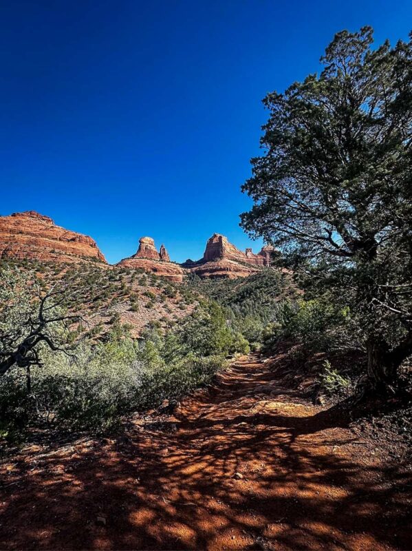
With stunning red rock scenery and gorgeous weather much of the year, nearly ALL Sedona hikes are fantastic. This trail guide highlights the best hikes in Sedona, Arizona for all levels of difficulty.

With its unique combination of distinctive red rocks, stone arches, hidden caves, ancient ruins, a whopping 200-plus trails, and perpetual sunshine, it’s hard to top Sedona as a hiking destination.
Add in the easy access from Phoenix, abundance of dispersed camping nearby, and excellent restaurants, and you could easily spend a week here.
Fortunately, even if you only have one day, you can tackle some of the best hikes in Sedona, Arizona. Trails start at an easy one mile round-trip and go (way) up from there, making it approachable regardless of how much time you have or your hiking skills.
Sedona Hiking Guide
We’ve included some extra info for planning your hiking trip in Sedona. Jump to the following sections (or just keep scrolling to see it all!).

1. Boynton Canyon Trail & Subway Cave
- Distance: 7.2 miles out and back
- Elevation gain: 964 feet
- Difficulty rating: Moderate
- View the trail guide
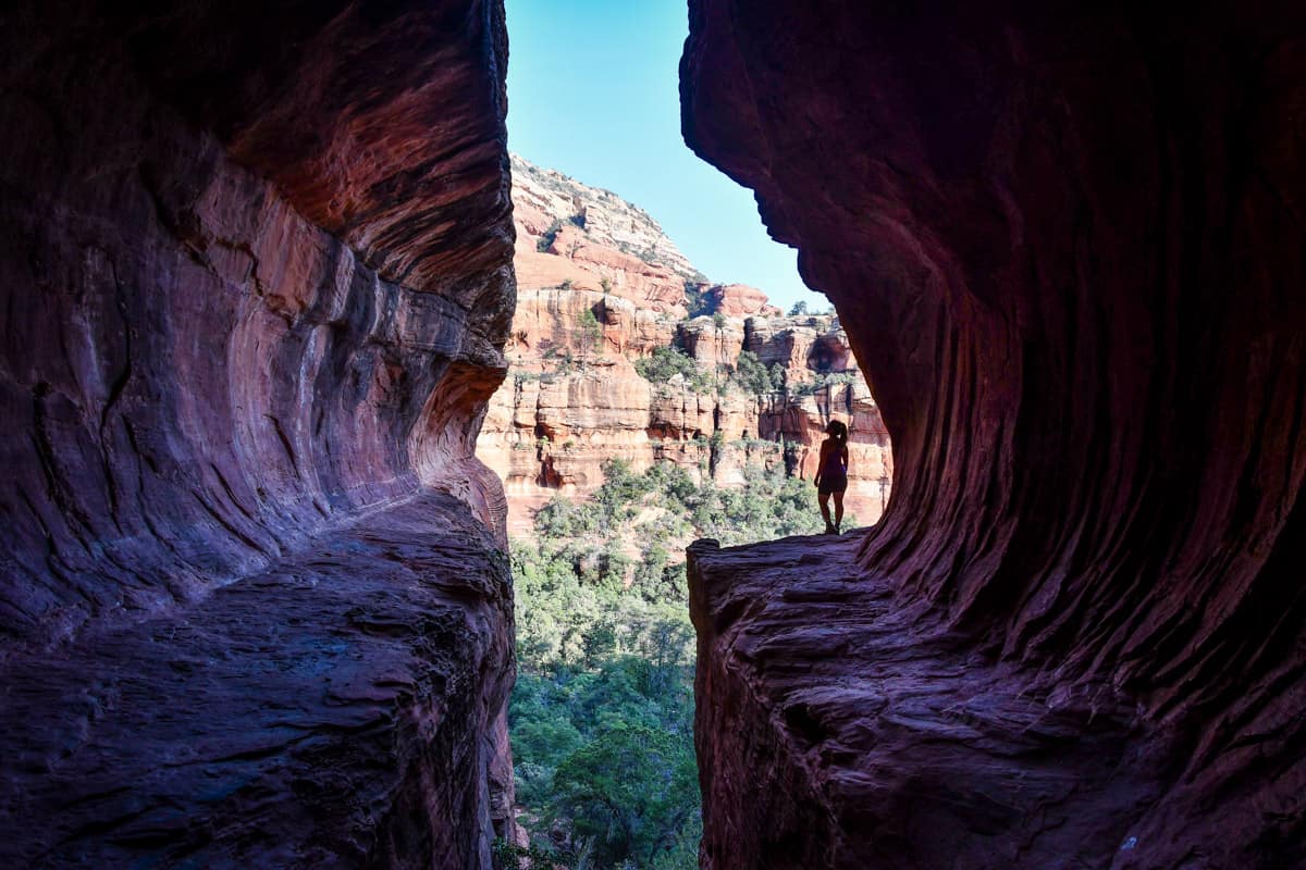
You’ve almost certainly seen pictures of the Subway Cave. Not only is the cave’s shape unique, but this is also genuinely one of the best hikes in Sedona Arizona, with gorgeous scenery and a major vortex site.
It’s important to note that the Subway Cave, or Keyhole Cave, is quite controversial.
Unfortunately, due to its recent popularity, nearby ancient Sinaguan ruins have suffered serious damage as people explore off-trail. Leave No Trace is always important, but especially so here. Please follow the official trail and be extremely respectful of the fragile, sacred surroundings.
Start on Boynton Canyon Trail, near the Enchantment Resort. To get to the cave, look carefully for a special Alligator Juniper tree at the 2-mile mark. Go right on the spur trail and 0.4 miles to the cave, which looks like a giant slot in the rocks.
You can walk up into the cave for that coveted photo op, but it’s the most challenging part of the hike, with a slick, steep walkway.
2. Courthouse Butte & Bell Rock Loop

- Distance: 3.6-mile loop
- Elevation gain: 340 feet
- Difficulty rating: Moderate
- View the trail notes
One of the most iconic red rock formations in Sedona is also one its most popular hikes. Located just off Highway 179, Bell Rock commands attention from anywhere in town.
Despite being rated moderate, this is more of an easy hike. The majority of the loop is flat, with the exception of some uneven terrain and rock steps. At the end, you can climb up Bell Rock for even better views.
If you do ascend Bell Rock, it’ll add 0.6 miles and 800 feet of elevation to your total. This short but steep add-on is what takes Bell Rock from easy to moderate.
On the north side, Courthouse Vista is the closest parking lot. It’s also the smallest, however. On the south side, you can park in the bigger Bell Rock Trailhead Parking Area, but it’s a further walk.
3. Cathedral Rock Trail

- Distance: 1.2 miles out and back
- Elevation gain: 740 feet
- Difficulty rating: Moderate
- View the trail notes
Cathedral Rock is easily one of the most popular hikes in Sedona. It’s also one of the steepest. Even the Forest Service says it’s “more of a rock climb than a hike.”
Park off Back O’ Beyond Road, then cross a wash and work your way up the spires. The trail is completely exposed and the surface is mostly slickrock. Luckily, several notches act as foot and handholds.
Follow the cairns, eventually ending up at a wide saddle between two spires with incredible 360-degree views.
4. Pyramid to Scorpion Trail Loop

- Distance: 2.2-mile loop
- Elevation gain: 288 feet
- Difficulty rating: Moderate
- View the trail notes
Of all the best hikes in Sedona Arizona, this ultra-scenic loop is one of the least crowded—despite showing off outstanding views of Cathedral Rock.
Both legs of the trail feel remote, and minimal signage makes it hard to follow at times, especially over slickrock. Look carefully for subtle cairns leading the way and branches blocking paths.
The Pyramid Trail takes you around the base of the namesake red pyramid rock, with snug sections of slippery trail. On the Scorpion Trail, views open up.
You can hike in either direction, but this section is fantastic at sunset, with a magical glow on Cathedral Rock.
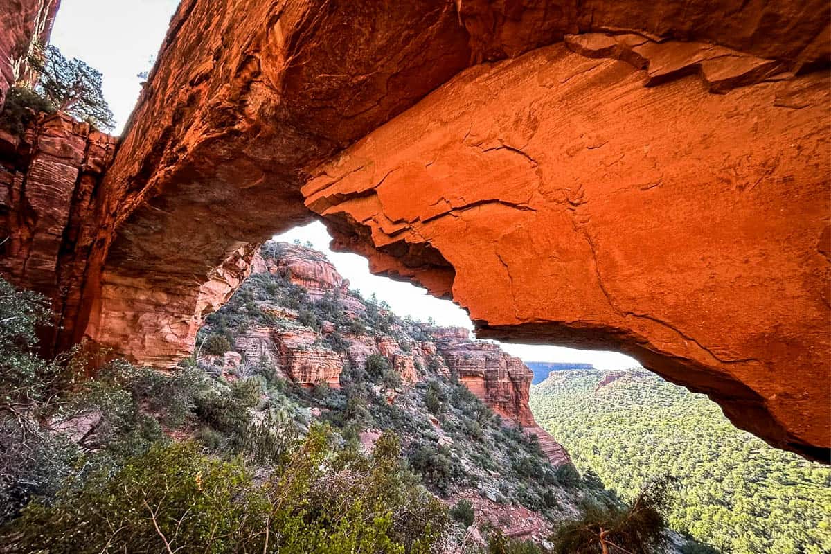
5. Birthing Cave Trail

- Distance: 1.9 miles out and back
- Elevation gain: 242 feet
- Difficulty rating: Moderate
- View the trail notes
Birthing Cave is one of the most accessible caves in Sedona—although you’ll still have to look for it. At an obvious fork on Long Canyon Trail, go left (away from the fence). As you approach the cliffs, follow the sounds of voices to find the cave.
Like many other best hikes in Sedona Arizona, the trail to Birthing Cave is flat and sandy. It isn’t until the end that the trail gets steeper and you have to scramble up the slick cave walls for the best views.
If you can’t park at Long Canyon Trailhead (this hike is VERY popular!), there’s a bigger lot at the Mescal Trailhead, half a mile away.
6. Devil’s Bridge Trail

- Distance: 3.9 miles out and back
- Elevation gain: 528 feet
- Difficulty rating: Moderate
- View the trail notes
You can’t even consider the best hikes in Sedona Arizona without mentioning Devil’s Bridge. One of the most iconic trails, Devil’s Bridge is deservedly on just about everyone’s Sedona bucket list.
The trail leads to a unique natural arch (the biggest one in Sedona!), the top of which is the ‘bridge,’ and you have the opportunity to walk across it. Don’t worry, it’s wider and not nearly as scary as it seems!
The most challenging thing about Devil’s Bridge is getting to the trailhead.
Unless you have a 4-wheel drive vehicle to access the trailhead, you’ll have to park at the Mescal Trailhead (4 miles round-trip; the most popular route) or take the shuttle to the Dry Creek parking lot.
We recommend trying to park at Mescal, because the walk from Dry Creek Road is longer and not so pleasant—it’s a dirt road popular with ATVs and Jeeps.
7. Airport Loop Trail

- Distance: 3.3-mile loop
- Elevation gain: 429 feet
- Difficulty rating: Moderate
- View the trail notes
Airport Loop takes you up and around the perimeter of Airport Mesa, also called Table Top Mountain. Enjoy wide open views over the city and some of Sedona’s most iconic formations, including Bell Rock and Cathedral Rock.
Not only is Airport Mesa home to the Sedona Airport, but it’s also one of the most accessible vortex sites in town.
The trail alternates between easy and slightly challenging, with rocky, uneven terrain and lots of up and down. It’s usually practically deserted, because most people park, quickly walk up to the vortex, and leave.
8. Seven Sacred Pools via Soldier Pass Trail
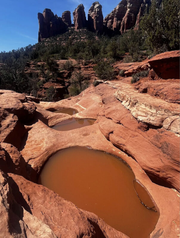
- Distance: 1.1 miles out and back
- Elevation gain: 90 feet
- Difficulty rating: Easy
- View the trail notes
Soldier Pass Trail is one of the best hikes in Sedona Arizona, especially for first-time visitors or families. The approachable terrain offers a great intro hike.
Highlights include a huge sinkhole, aptly named Devil’s Kitchen, and the Seven Sacred Pools (which, FYI, often don’t have any water in them).
Many people choose to take a spur trail to Soldier Pass Cave, which is hidden from view but not at all a secret. It’s exactly 1.3 miles from the trailhead, slightly more than doubling your total distance.
Aside from being busy with foot traffic, Soldier Pass sees a ton of ATVs. A very popular off-roading route runs parallel to the trail, and it can be dusty and loud.
Soldier Pass also has one of the smallest parking lots in Sedona, accommodating just 14 vehicles. The lot is locked every night, whether or not cars are there. Even when it’s open on non-shuttle days, you’ll need to arrive very early or hope you get lucky.
Alternatively, you can park at the larger Brins Mesa Trailhead, adding one mile each way.
9. Munds Wagon Trail to Merry Go Round Rock
- Distance: 6.5 miles out and back
- Elevation gain: 1,100 feet
- Difficulty rating: Moderate
- View the trail notes
Merry Go Round Rock has become one of the most famous photo spots in Sedona in recent years. Getting to it, however, is not exactly straightforward.
Located off Schnebly Hill Road, a popular destination for off-roading enthusiasts, you need to hike or have access to a high-clearance 4WD vehicle.
Luckily, the hike is moderate and little-traveled (most people take Jeep tours or drive). It also has fantastic views throughout! Start from the Munds Wagon trailhead, then follow the trail up, up, up toward Merry Go Round Rock.
Once you’re there, you can also look for the hidden cave below, wildly popular for photos. Beware, however, that getting to it requires a sketchy scramble down the cliff.
10. Bear Mountain Trail
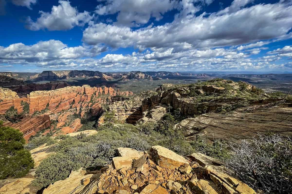
- Distance: 4.6 miles out and back
- Elevation gain: 1,988 feet
- Difficulty rating: Challenging
- View the trail notes
Sedona hikes are known for being relatively short and sweet, with huge payoffs. Bear Mountain is a glaring exception in the ‘sweet’ department, with steep, tough elevation gains making this hike genuinely strenuous.
Those up for the challenge are rewarded with 360-degree views over Sedona and even to Flagstaff’s snow-capped San Francisco. High-up mountain views are rare here!
The trail is relentless, with the initial flat stretch less than 0.3 miles. From there it’s a never-ending ascent over loose rocks and deceptive false summits. And coming down is just as tough, especially on the knees.
Insider tip: although it didn’t make our list of the best hikes in Sedona Arizona, Doe Mountain offers similar views for less than half the distance and elevation gain. And it’s right down the road!
11. Fay Canyon Arch Trail
- Distance: 1.5 miles out and back
- Elevation gain: 246 feet
- Difficulty rating: Moderate
- View the trail notes
Hidden gems are rare in Sedona, but Fay Canyon Arch is an exception. This lovely, mostly easy-going trail passes through brushy forest and towering red cliffs.
The official trail takes you into Fay Canyon, but you can hike up to the arch…if you know where to look. Exactly 0.5 miles in, look for the unmarked spur trail to your right. This section is steep, rocky, and sandy, earning that ‘moderate’ rating.
From a distance, the arch doesn’t seem all that impressive, but stick with it—the up-close view makes the entire hike well worth it!
12. Hangover Trail
- Distance: 6.1 miles out and back
- Elevation gain: 890 feet
- Difficulty rating: Moderate to challenging
- View the trail notes
Hangover Trail is better known as an expert mountain biking trail (the Sedona Singletrack map actually describes it as “beyond advanced!”), but it’s also a great hike.
Start from the Huckaby Trailhead, then take Munds Wagon Trail to Hangover. Here, the terrain gets significantly more technical. The trail is steep, narrow, and exposed, especially toward the end, and you’ll walk across expanses of slickrock.
The views are outstanding at the end and the trail is rarely crowded, so it’s well worth the effort.
13. Brins Mesa via Brins Ridge Trail

- Distance: 4.1 miles out and back
- Elevation gain: 890 feet
- Difficulty rating: Moderate
- View the trail notes
Brins Mesa Trail runs almost parallel to Soldier Pass, one of the other best hikes in Sedona Arizona. In fact, many people hike Brins Mesa and Soldier Pass as a loop.
To hike Brins Mesa on its own, start at the parking lot for Brins Mesa/Jim Thompson Trailhead. Most of the hike is flat and sandy, but there is one big stair-like climb. The good news is, the views get better as you ascend!
At the top of the ridge, look to your right for a side trail up Brins Mesa. It’s hard to find, as it’s not well marked. You’ll know when you find it by the stunning 360-degree views.
14. Rabbit Ears and Little Rock Loop

- Distance: 5.5-mile loop
- Elevation gain: 757 feet
- Difficulty rating: Moderate
- View the trail notes
You can find two of the best hikes in Sedona Arizona in the Village of Oak Creek, although there’s a good chance you’ve never heard of either.
The Rabbit Ears and Little Rock trails, forming a loop, were re-routed and renamed in 2021, now part of the Big Park Loop Trail system.
You can hike the loop in either direction, but we recommend counter-clockwise, tackling Rabbit Ears first. Not only does this get the biggest climb out of the way early, it also offers in-your-face views of Cathedral Rock the entire way down.
15. Walnut Canyon Island Trail
- Distance: 1-mile loop
- Elevation gain: 300 feet
- Difficulty rating: Moderate
- View the trail notes
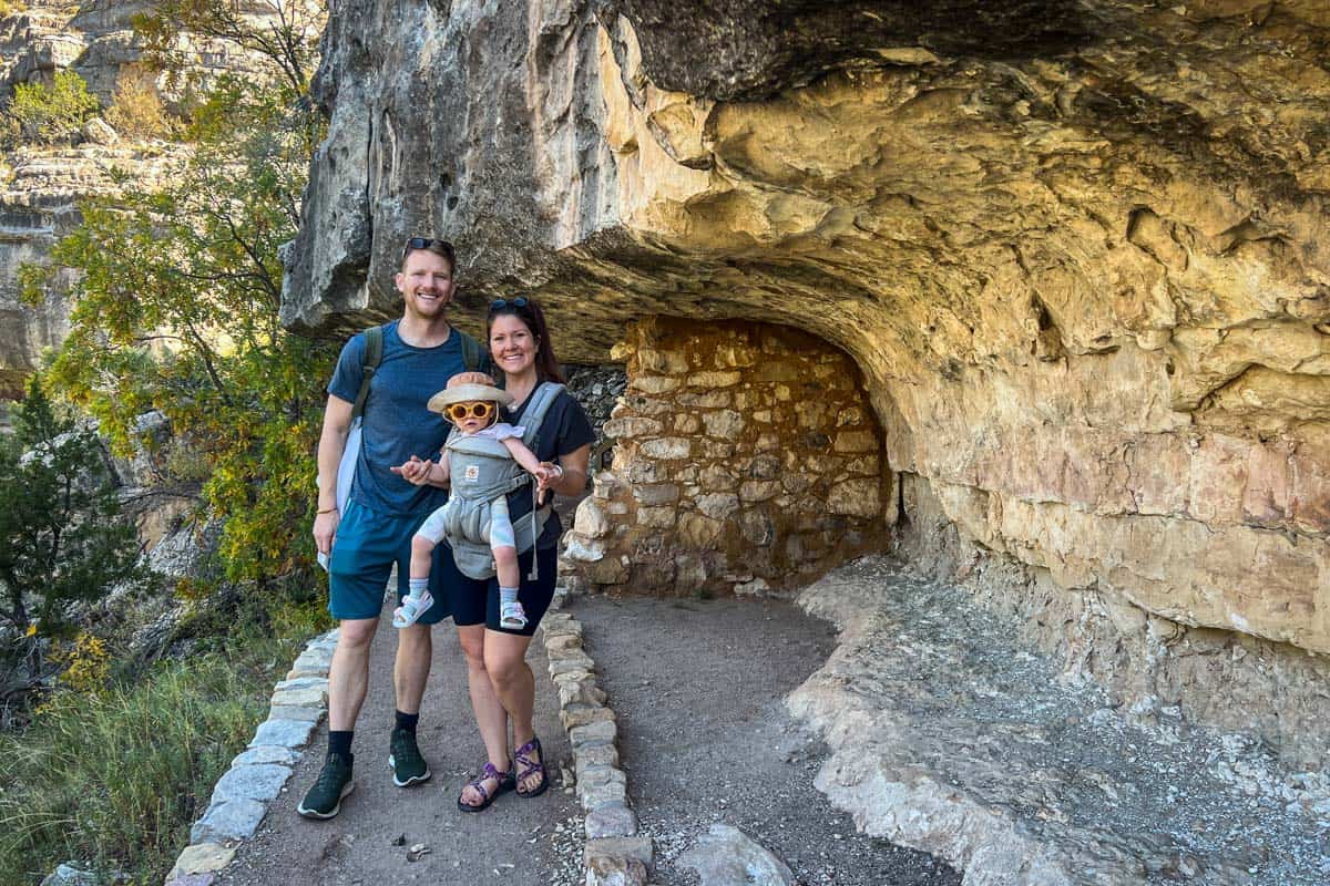
About one hour north of Sedona near Flagstaff, the Island Trail takes you on a literal walk back in time. 700 years back!
The trail is in Walnut Canyon National Monument, which preserves Sinauguan cliff dwellings. You’ll walk by 25 individual structures, plus see others across the canyon.
Although it’s short, Island Trail is steep, taking you nearly 200 feet into the canyon (and back up on the way out). You’ll climb over 730 stairs! Walnut Canyon also sits at over 7,000 feet in elevation, adding a challenge.
Sedona hiking shuttle

The totally FREE Sedona Shuttle helps ease traffic and parking issues at popular trailheads. It runs 7:00 am to about 6:00 pm Thursday-Sunday year-round, and daily during spring break and some major holidays.
Trails the shuttle serves include Devil’s Bridge, Soldier Pass/Seven Sacred Pools, Bell Rock, and Cathedral Rock.
Importantly, when the shuttle is running, parking lots at these trailheads are closed to vehicles completely.
Simply park at one of the city’s two park n’ ride lots, then catch the next available shuttle. Check the official website for exact operating times.
Best time to go hiking in Sedona, Arizona

The best time to hike in Sedona is any season but summer (seriously). Mid- to late fall and spring are the very best times, but winter has serious appeal, too.
Fall and spring bring mild, perpetually sunny weather and pops of color from foliage and wildflowers. However, these are also the busiest seasons in Sedona. Expect heavy traffic, congested trails, and limited parking.
Winter is mild and can be crowded also, but you have the opportunity to experience “Snowdona.”
Summer is the worst season because of Arizona’s infamous scorching heat. If you absolutely must visit then, bring a TON of water and get an extremely early start.
What to pack for hiking in Sedona

- Navigation: we recommend using Alltrails+ to download the offline trail map
- Get your first week of using Alltrails+ for FREE when you sign up using our link!
- Hiking daypack or hiking backpack
- Water bottles and/or bladder for your Camelbak
- Bug repellant
- Sun protection: sunscreen, hat, sun glasses
- Headlamp (if you’re hiking close to sunrise/sunset)
- Camera/tripod (this one’s our favorite for hiking)
- Lots of layers (here is a great resource if you’re wondering what to wear hiking)
- Comfortable hiking boots or shoes
- Hiking poles (optional)
- Plenty of snacks: check out our favorite hiking snacks here!
Be sure to download our FREE hiking packing list before your next trip and never leave another essential behind again!

Round up of the best hikes in Sedona, Arizona
Here’s a roundup of all the best hikes in Sedona so you can see everything in one place.
- Boynton Canyon Trail & Subway Cave
- Courthouse Butte & Bell Rock Loop
- Walnut Canyon Island Trail
- Cathedral Rock Trail
- Birthing Cave Trail
- Devil’s Bridge Trail
- Airport Loop Trail
- Seven Sacred Pools via Soldiers Pass Trail
- Munds Wagon Trail to Merry Go Round Rock
- Bear Mountain Trail
- Fay Canyon Arch Trail
- Hangover Trail
- Brins Mesa via Brins Ridge Trail
- Rabbit Ears and Little Rock Loop
- Pyramid to Scorpion Trail Loop
You may also like…
- Easy Hikes in Sedona, Arizona for Beginners
- What to Wear Hiking in Every Season
- Best Hiking Snacks: Healthy & Delicious Trekking Food
- Hiking Lunch Ideas to Keep You Fed on the Trail
Save this article on Pinterest for later!


We want to hear from you!
Which of the best hikes in Sedona Arizona are you most excited to tackle? Do you have a favorite hike in Sedona you think we should add to this list? Leave us a comment below and we’ll do our best to get back to you!